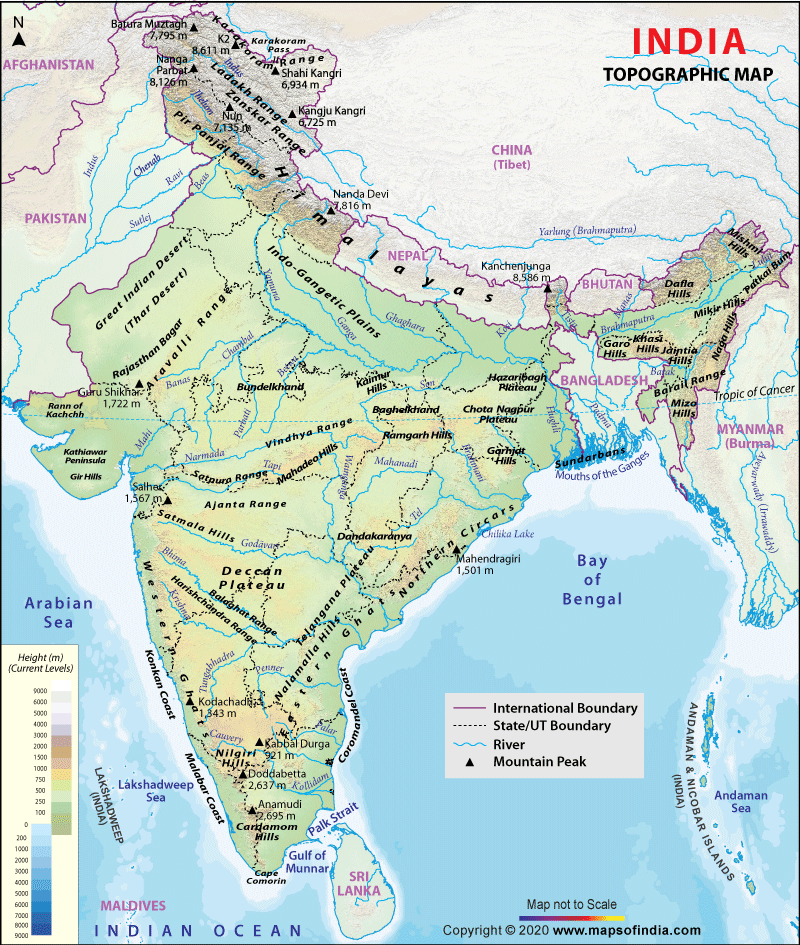
A map depicting the configuration of the earth’s surface, called the “relief,” by means of contours, form lines, shading, tinting, or relief models. This particular map is a hypsometric map of the Republic of Macedonia, more specifically of Bitola, which is a city in the southwestern part of the republic. This map uses the color to distinguish the extent of the variable.
Wednesday, August 6, 2008
PLSS maps
The Public Land Survey System (PLSS) is a method used in the United States to survey and identify land parcels, particularly for titles and deeds of rural, wild or undeveloped land. Its basic units of area are the township and section. It was used in the U.S. to help inhabit the West, it was used instead of the metes and bounds system, a British system, that was used in the original 13 colonies. This particular map which I found on ancestry.com is actually a PLSS map of Alabama. As you can see it is very exact and regismented in its dividing of land parcels.
Cadastral maps
Cadastral maps show how land is divided into real property, and sometimes the kinds of built improvements. They show land ownership, rights to land access and use, and obligations. They are best known for their use in taxation and this is particularly important in the U.S. Its significance comes mainly from its role in governance and in land development and speculation. This cadastral map is from the website of the DALIS project and shows a cadastral map of Delaware County, Ohio.
Thematic Maps
Thematic maps are data maps of a specific subject or for a specific purpose. Statistical thematic maps include a variety of different map types such as choropleth or shaded maps, dot maps, and proportional symbol maps. They are a special purpose maps and generally concentrate on a single theme. This map that I found on a universities’ geography class website shows the population change in the U.S. between 1990 and 1996, as you can see it is quite a specific map.
Topographic Map
Topographic maps show the physical characteristics of land in an area and the changes in the landscape. Topographic maps are characterized by large-scale detail and quantitative representation of relief, usually using contour lines in modern mapping, but historically using a variety of methods. Traditional definitions require a topographic map to show both natural and man-made features. This particular map is a topographic map of Inda that I got from a website that is called mapsofindia.com.
Planimetric Map
A planimetric map is a map that represents only the horizontal positions of features and not the vertical positions, like heights, the way in which a topographic map would show. This map is from the USGS website and it is a planimetric map of Iraq. It contains information on international boundaries, major cities, roads, railroads, airfields, seas, rivers, lakes, and oil refineries.
Tuesday, July 22, 2008
Standardized choropleth maps
Choropleth maps portray quantitative data as a color showing the density, percent, average value, or quantity of a phenomenon within the boundary of a geographic area. In a standardized choropleth map the data are standardized so that it may allow the comparison of the distribution among different areas. This particular map deals with the population density of Costa Rica. The distributions are able to be compared to each other.
Subscribe to:
Posts (Atom)